Date: 4/27/2015
Location Name: Mondawmin Mall
Incident explanation: Riots began near Mondawmin Mall on Monday afternoon.
Location: 39.318926, -76.655932
Photo:
width: 300
icon-marker: large_red
Location Name: Mondawmin Mall
Incident explanation: Riots began near Mondawmin Mall on Monday afternoon.
Location: 39.318926, -76.655932
Photo:
width: 300
icon-marker: large_red
Date: 4/27/2015
Location Name: Gallery Grill
Incident explanation: Property damage reported
Location: 39.296197, -76.616410
Photo:
width: 300
icon-marker: large_red
Location Name: Gallery Grill
Incident explanation: Property damage reported
Location: 39.296197, -76.616410
Photo:
width: 300
icon-marker: large_red
Date: 4/27/2015
Location Name: AJ Mini Mart
Incident explanation: Property damage and looting reported.
Location: 39.299908, -76.647699
Photo:
width: 300
icon-marker: large_red
Location Name: AJ Mini Mart
Incident explanation: Property damage and looting reported.
Location: 39.299908, -76.647699
Photo:
width: 300
icon-marker: large_red
Date: 4/27/2015
Location Name: Hae-Tteuneun Store
Incident explanation: Property damage reported.
Location: 39.306703, -76.644801
Photo:
width: 300
icon-marker: large_red
Location Name: Hae-Tteuneun Store
Incident explanation: Property damage reported.
Location: 39.306703, -76.644801
Photo:
width: 300
icon-marker: large_red
Date: 4/27/2015
Location Name: Lakein's Jewelers of Hamilton
Incident explanation: Property damage and looting reported.
Location: 39.351441, -76.562579
Photo:
width: 300
icon-marker: large_red
Location Name: Lakein's Jewelers of Hamilton
Incident explanation: Property damage and looting reported.
Location: 39.351441, -76.562579
Photo:
width: 300
icon-marker: large_red
Date: 4/27/2015
Location Name: 7-11 at N. Charles Street and Centre Street
Incident explanation: Broken windows and looting reported.
Location: 39.296235, -76.615428
Photo:
width: 300
icon-marker: large_red
Location Name: 7-11 at N. Charles Street and Centre Street
Incident explanation: Broken windows and looting reported.
Location: 39.296235, -76.615428
Photo:
width: 300
icon-marker: large_red
Date: 4/27/2015
Location Name: Sav-a-lot and Rite Aid in Bolton Hill
Incident explanation: Property damage and looting reported.
Location: 39.307305, -76.628808
Photo:
width: 300
icon-marker: large_red
Location Name: Sav-a-lot and Rite Aid in Bolton Hill
Incident explanation: Property damage and looting reported.
Location: 39.307305, -76.628808
Photo:
width: 300
icon-marker: large_red
Date: 4/27/2015
Location Name: Ocala Ave. off Reisterstown Rd.
Incident explanation: Car fire
Location: 39.320818, -76.654636
Photo:
width: 300
icon-marker: large_red
Location Name: Ocala Ave. off Reisterstown Rd.
Incident explanation: Car fire
Location: 39.320818, -76.654636
Photo:
width: 300
icon-marker: large_red
Date: 4/27/2015
Location Name: 7-11 at 300 N. Charles St.
Incident explanation: Property damage and looting reported.
Location: 39.292597, -76.615556
Photo:
width: 300
icon-marker: large_red
Location Name: 7-11 at 300 N. Charles St.
Incident explanation: Property damage and looting reported.
Location: 39.292597, -76.615556
Photo:
width: 300
icon-marker: large_red
Date: 4/27/2015
Location Name: Midtown BBQ & Brew
Incident explanation: Property damage reported
Location: 39.296286, -76.614637
Photo:
width: 300
icon-marker: large_red
Location Name: Midtown BBQ & Brew
Incident explanation: Property damage reported
Location: 39.296286, -76.614637
Photo:
width: 300
icon-marker: large_red
Date: 4/27/2015
Location Name: Sports Mart
Incident explanation: Property damage and looting reported.
Location: 39.294198, -76.605682
Photo:
width: 300
icon-marker: large_red
Location Name: Sports Mart
Incident explanation: Property damage and looting reported.
Location: 39.294198, -76.605682
Photo:
width: 300
icon-marker: large_red
Date: 4/27/2015
Location Name: Annapurna Grocery
Incident explanation: Property damage reported.
Location: 39.293397, -76.615486
Photo:
width: 300
icon-marker: large_red
Location Name: Annapurna Grocery
Incident explanation: Property damage reported.
Location: 39.293397, -76.615486
Photo:
width: 300
icon-marker: large_red
Date: 4/27/2015
Location Name: Trinacria Italian Cafe
Incident explanation: Property damage reported.
Location: 39.296147, -76.618141
Photo:
width: 300
icon-marker: large_red
Location Name: Trinacria Italian Cafe
Incident explanation: Property damage reported.
Location: 39.296147, -76.618141
Photo:
width: 300
icon-marker: large_red
Date: 4/27/2015
Location Name: Mondawmin Mall
Incident explanation: Around 7:30 p.m., Baltimore police reported property damage and looting at the mall.
Location: 39.317279, -76.655287
Photo:
width: 300
icon-marker: large_red
Location Name: Mondawmin Mall
Incident explanation: Around 7:30 p.m., Baltimore police reported property damage and looting at the mall.
Location: 39.317279, -76.655287
Photo:
width: 300
icon-marker: large_red
Date: 4/27/2015
Location Name: Federal St. and Gay St.
Incident explanation: Large building fire. The fire has not been confirmed as connected to the riots.
Location: 39.308796, -76.588435
Photo:
width: 300
icon-marker: large_red
Location Name: Federal St. and Gay St.
Incident explanation: Large building fire. The fire has not been confirmed as connected to the riots.
Location: 39.308796, -76.588435
Photo:
width: 300
icon-marker: large_red
Date: 4/27/2015
Location Name: Monument St. and Collington St.
Incident explanation: Property damage and looting reported.
Location: 39.298679, -76.586656
Photo:
width: 0
icon-marker: large_red
Location Name: Monument St. and Collington St.
Incident explanation: Property damage and looting reported.
Location: 39.298679, -76.586656
Photo:
width: 0
icon-marker: large_red
Date: 4/27/2015
Location Name: CVS Pharmacy
Incident explanation: Demonstrators looted and set fire to the CVS Pharmacy at North and Pennsylvania avenues.
Location: 39.310389, -76.642636
Photo:
width: 300
icon-marker: large_red
Location Name: CVS Pharmacy
Incident explanation: Demonstrators looted and set fire to the CVS Pharmacy at North and Pennsylvania avenues.
Location: 39.310389, -76.642636
Photo:
width: 300
icon-marker: large_red
Date: 4/27/2015
Location Name: Cafe Poupon on Charles St.
Incident explanation: Property damage reported.
Location: 39.291762, -76.614990
Photo:
width: 300
icon-marker: large_red
Location Name: Cafe Poupon on Charles St.
Incident explanation: Property damage reported.
Location: 39.291762, -76.614990
Photo:
width: 300
icon-marker: large_red
Date: 4/27/2015
Location Name: Rite Aid on Lexington St.
Incident explanation: Property damage reported.
Location: 39.291385, -76.619964
Photo:
width: 300
icon-marker: large_red
Location Name: Rite Aid on Lexington St.
Incident explanation: Property damage reported.
Location: 39.291385, -76.619964
Photo:
width: 300
icon-marker: large_red
Date: 4/27/2015
Location Name: J Mart Wig Beauty Supply & Gift
Incident explanation: Property damage and looting reported.
Location: 39.285131, -76.650035
Photo:
width: 300
icon-marker: large_red
Location Name: J Mart Wig Beauty Supply & Gift
Incident explanation: Property damage and looting reported.
Location: 39.285131, -76.650035
Photo:
width: 300
icon-marker: large_red
Date: 4/27/2015
Location Name: North and Pennsylvania avenues
Incident explanation: Demonstrators set an MTA vehicle on fire at North and Pennsylvania avenues.
Location: 39.310113, -76.642545
Photo:
width: 300
icon-marker: large_red
Location Name: North and Pennsylvania avenues
Incident explanation: Demonstrators set an MTA vehicle on fire at North and Pennsylvania avenues.
Location: 39.310113, -76.642545
Photo:
width: 300
icon-marker: large_red
Date: 4/27/2015
Location Name: Fulton Avenue and North Avenue
Incident explanation: Baltimore police report property damage.
Location: 39.309858, -76.646486
Photo:
width: 300
icon-marker: large_red
Location Name: Fulton Avenue and North Avenue
Incident explanation: Baltimore police report property damage.
Location: 39.309858, -76.646486
Photo:
width: 300
icon-marker: large_red
Date: 4/27/2015
Location Name: Ted's Musicians Shop
Incident explanation: Property damage reported
Location: 39.296258, -76.614788
Photo:
width: 300
icon-marker: large_red
Location Name: Ted's Musicians Shop
Incident explanation: Property damage reported
Location: 39.296258, -76.614788
Photo:
width: 300
icon-marker: large_red
Date: 4/27/2015
Location Name: Loading Dock Discount Liquors
Incident explanation: Property damage reported.
Location: 39.284733, -76.586858
Photo:
width: 300
icon-marker: large_red
Location Name: Loading Dock Discount Liquors
Incident explanation: Property damage reported.
Location: 39.284733, -76.586858
Photo:
width: 300
icon-marker: large_red
Date: 4/27/2015
Location Name: ACE Cash Express
Incident explanation: Property damage and looting reported.
Location: 39.310245, -76.643084
Photo:
width: 300
icon-marker: large_red
Location Name: ACE Cash Express
Incident explanation: Property damage and looting reported.
Location: 39.310245, -76.643084
Photo:
width: 300
icon-marker: large_red
Date: 4/27/2015
Location Name: Binta's African Hair
Incident explanation: TV, hair extensions and products stolen from Binta's African Hair on Eutaw St.
Location: 39.296443, -76.621521
Photo:
width: 300
icon-marker: large_red
Location Name: Binta's African Hair
Incident explanation: TV, hair extensions and products stolen from Binta's African Hair on Eutaw St.
Location: 39.296443, -76.621521
Photo:
width: 300
icon-marker: large_red
Date: 4/27/2015
Location Name: Lexington Market
Incident explanation: Property damage and looting reported.
Location: 39.291688, -76.621747
Photo:
width: 300
icon-marker: large_red
Location Name: Lexington Market
Incident explanation: Property damage and looting reported.
Location: 39.291688, -76.621747
Photo:
width: 300
icon-marker: large_red
Date: 4/27/2015
Location Name: Virginia Ave. and Reisterstown Rd.
Incident explanation: Shots fired at an officer. The officer was not hit.
Location: 39.340680, -76.672594
Photo:
width: 0
icon-marker: large_red
Location Name: Virginia Ave. and Reisterstown Rd.
Incident explanation: Shots fired at an officer. The officer was not hit.
Location: 39.340680, -76.672594
Photo:
width: 0
icon-marker: large_red
Date: 4/27/2015
Location Name: CapitolMac
Incident explanation: Property damage reported
Location: 39.283091, -76.593594
Photo:
width: 300
icon-marker: large_red
Location Name: CapitolMac
Incident explanation: Property damage reported
Location: 39.283091, -76.593594
Photo:
width: 300
icon-marker: large_red
Date: 4/27/2015
Location Name: 2111 West Pratt St.
Incident explanation: Three-alarm building fire reported.
Location: 39.284968, -76.650365
Photo:
width: 300
icon-marker: large_red
Location Name: 2111 West Pratt St.
Incident explanation: Three-alarm building fire reported.
Location: 39.284968, -76.650365
Photo:
width: 300
icon-marker: large_red
Date: 4/27/2015
Location Name: 7-11 at W. Franklin St. near Eutaw St.
Incident explanation: Property damage and looting reported.
Location: 39.294832, -76.621266
Photo:
width: 300
icon-marker: large_red
Location Name: 7-11 at W. Franklin St. near Eutaw St.
Incident explanation: Property damage and looting reported.
Location: 39.294832, -76.621266
Photo:
width: 300
icon-marker: large_red
Date: 4/27/2015
Location Name: Cozy Corner
Incident explanation: Reported property damage
Location: 39.296120, -76.616806
Photo:
width: 300
icon-marker: large_red
Location Name: Cozy Corner
Incident explanation: Reported property damage
Location: 39.296120, -76.616806
Photo:
width: 300
icon-marker: large_red
Date: 4/27/2015
Location Name: Gold Apple Jewelry
Incident explanation: Property damage reported.
Location: 39.290533, -76.614563
Photo:
width: 300
icon-marker: large_red
Location Name: Gold Apple Jewelry
Incident explanation: Property damage reported.
Location: 39.290533, -76.614563
Photo:
width: 300
icon-marker: large_red
Date: 4/27/2015
Location Name: Variety -n- Cellphone Center
Incident explanation: Property damage and looting reported.
Location: 39.309679, -76.646323
Photo:
width: 300
icon-marker: large_red
Location Name: Variety -n- Cellphone Center
Incident explanation: Property damage and looting reported.
Location: 39.309679, -76.646323
Photo:
width: 300
icon-marker: large_red
Date: 4/27/2015
Location Name: CVS Pharmacy at 5407 Harford Rd in Hamilton
Incident explanation: Property damage reported.
Location: 39.351352, -76.562023
Photo:
width: 300
icon-marker: large_red
Location Name: CVS Pharmacy at 5407 Harford Rd in Hamilton
Incident explanation: Property damage reported.
Location: 39.351352, -76.562023
Photo:
width: 300
icon-marker: large_red
Date: 4/27/2015
Location Name: Sneaky Feet shoe store
Incident explanation: Property damage and looting reported.
Location: 39.286381, -76.570544
Photo:
width: 300
icon-marker: large_red
Location Name: Sneaky Feet shoe store
Incident explanation: Property damage and looting reported.
Location: 39.286381, -76.570544
Photo:
width: 300
icon-marker: large_red
Date: 4/27/2015
Location Name: W. Saratoga St and N. MLK Jr. Blvd.
Incident explanation: Structure fire reported.
Location: 39.292712, -76.627778
Photo:
width: 0
icon-marker: large_red
Location Name: W. Saratoga St and N. MLK Jr. Blvd.
Incident explanation: Structure fire reported.
Location: 39.292712, -76.627778
Photo:
width: 0
icon-marker: large_red
Date: 4/27/2015
Location Name: N. Hilton St. and Piedmont Ave.
Incident explanation: Structure fire reported.
Location: 39.316339, -76.672860
Photo:
width: 0
icon-marker: large_red
Location Name: N. Hilton St. and Piedmont Ave.
Incident explanation: Structure fire reported.
Location: 39.316339, -76.672860
Photo:
width: 0
icon-marker: large_red
Date: 4/27/2015
Location Name: Belle Hardware
Incident explanation: Property damage reported.
(Photo by Mark Makela/Getty Images)
Location: 39.307519, -76.628396
Photo:
width: 300
icon-marker: large_red
Location Name: Belle Hardware
Incident explanation: Property damage reported.
(Photo by Mark Makela/Getty Images)
Location: 39.307519, -76.628396
Photo:
width: 300
icon-marker: large_red
Date: 4/27/2015
Location Name: Bolton Hill Laundromat
Incident explanation: Property damage reported.
(Photo by Mark Makela/Getty Images)
Location: 39.307459, -76.628505
Photo:
width: 300
icon-marker: large_red
Location Name: Bolton Hill Laundromat
Incident explanation: Property damage reported.
(Photo by Mark Makela/Getty Images)
Location: 39.307459, -76.628505
Photo:
width: 300
icon-marker: large_red
Date: 4/27/2015
Location Name: 200 block of N. Howard St.
Incident explanation: Property damage reported.
Location: 39.291524, -76.620666
Photo:
width: 300
icon-marker: large_red
Location Name: 200 block of N. Howard St.
Incident explanation: Property damage reported.
Location: 39.291524, -76.620666
Photo:
width: 300
icon-marker: large_red
Date: 4/27/2015
Location Name: Cricket store
Incident explanation: Property damage and looting reported.
Location: 39.355360, -76.609992
Photo: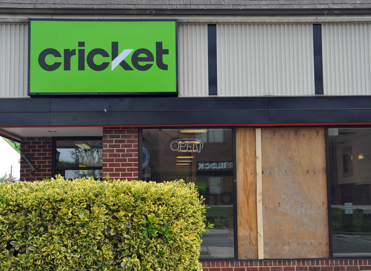
width: 300
icon-marker: large_red
Location Name: Cricket store
Incident explanation: Property damage and looting reported.
Location: 39.355360, -76.609992
Photo:
width: 300
icon-marker: large_red
Date: 4/27/2015
Location Name: 1700 block of Harman Ave.
Incident explanation: Structure fire reported.
Location: 39.268124, -76.653775
Photo:
width: 0
icon-marker: large_red
Location Name: 1700 block of Harman Ave.
Incident explanation: Structure fire reported.
Location: 39.268124, -76.653775
Photo:
width: 0
icon-marker: large_red
Date: 4/27/2015
Location Name: Westside Shopping Center
Incident explanation: Structure fire reported.
Location: 39.284165, -76.654532
Photo:
width: 0
icon-marker: large_red
Location Name: Westside Shopping Center
Incident explanation: Structure fire reported.
Location: 39.284165, -76.654532
Photo:
width: 0
icon-marker: large_red
Date: 4/27/2015
Location Name: 2500 block of W. Franklin St.
Incident explanation: Structure fire reported.
Location: 39.293325, -76.656241
Photo:
width: 0
icon-marker: large_red
Location Name: 2500 block of W. Franklin St.
Incident explanation: Structure fire reported.
Location: 39.293325, -76.656241
Photo:
width: 0
icon-marker: large_red
Date: 4/27/2015
Location Name: Mondawmin Mall bus stop
Incident explanation: Property damage reported.
(Photo by Drew Angerer/Getty Images)
Location: 39.317901, -76.652945
Photo:
width: 300
icon-marker: large_red
Location Name: Mondawmin Mall bus stop
Incident explanation: Property damage reported.
(Photo by Drew Angerer/Getty Images)
Location: 39.317901, -76.652945
Photo:
width: 300
icon-marker: large_red
Date: 4/27/2015
Location Name: Rainbow Shop
Incident explanation: Property damage and looting reported.
Location: 39.358298, -76.595727
Photo:
width: 300
icon-marker: large_red
Location Name: Rainbow Shop
Incident explanation: Property damage and looting reported.
Location: 39.358298, -76.595727
Photo:
width: 300
icon-marker: large_red
Date: 4/27/2015
Location Name: 2400 block of E. Monument St.
Incident explanation: Structure fire reported.
Location: 39.298956, -76.583594
Photo:
width: 0
icon-marker: large_red
Location Name: 2400 block of E. Monument St.
Incident explanation: Structure fire reported.
Location: 39.298956, -76.583594
Photo:
width: 0
icon-marker: large_red
Date: 4/27/2015
Location Name: 1800 block of Pennsylvania Ave.
Incident explanation: Structure fire reported.
Location: 39.304324, -76.635800
Photo:
width: 0
icon-marker: large_red
Location Name: 1800 block of Pennsylvania Ave.
Incident explanation: Structure fire reported.
Location: 39.304324, -76.635800
Photo:
width: 0
icon-marker: large_red
Date: 4/27/2015
Location Name: Oxford Tavern
Incident explanation: Property damage and looting reported.
(AP Photo/Matt Rourke)
Location: 39.309662, -76.646270
Photo:
width: 300
icon-marker: large_red
Location Name: Oxford Tavern
Incident explanation: Property damage and looting reported.
(AP Photo/Matt Rourke)
Location: 39.309662, -76.646270
Photo:
width: 300
icon-marker: large_red
Date: 4/27/2015
Location Name: N. Monroe St. and Clifton Ave.
Incident explanation: Car fire reported.
(Photo by Andrew Burton/Getty Images)
Location: 39.311953, -76.648262
Photo:
width: 300
icon-marker: large_red
Location Name: N. Monroe St. and Clifton Ave.
Incident explanation: Car fire reported.
(Photo by Andrew Burton/Getty Images)
Location: 39.311953, -76.648262
Photo:
width: 300
icon-marker: large_red
Date: 4/27/2015
Location Name: N. Chester St.
Incident explanation: Passenger van fire reported.
Location: 39.308925, -76.588417
Photo:
width: 300
icon-marker: large_red
Location Name: N. Chester St.
Incident explanation: Passenger van fire reported.
Location: 39.308925, -76.588417
Photo:
width: 300
icon-marker: large_red
Date: 4/27/2015
Location Name: Taco Bell on Pulaski Highway
Incident explanation: Property damage and looting reported.
Location: 39.295653, -76.570243
Photo:
width: 300
icon-marker: large_red
Location Name: Taco Bell on Pulaski Highway
Incident explanation: Property damage and looting reported.
Location: 39.295653, -76.570243
Photo:
width: 300
icon-marker: large_red
Date: 4/27/2015
Location Name: King Grocery Mart
Incident explanation: Property damage reported.
Location: 39.309709, -76.645061
Photo:
width: 300
icon-marker: large_red
Location Name: King Grocery Mart
Incident explanation: Property damage reported.
Location: 39.309709, -76.645061
Photo:
width: 300
icon-marker: large_red
Date: 4/27/2015
Location Name: Care One Pharmacy
Incident explanation: Property damage and looting reported.
(Photo by Chip Somodevilla/Getty Images)
Location: 39.314663, -76.647829
Photo:
width: 300
icon-marker: large_red
Location Name: Care One Pharmacy
Incident explanation: Property damage and looting reported.
(Photo by Chip Somodevilla/Getty Images)
Location: 39.314663, -76.647829
Photo:
width: 300
icon-marker: large_red
Date: 4/27/2015
Location Name: CVS Pharmacy
Incident explanation: Property damage and looting reported.
Location: 39.352242, -76.610292
Photo: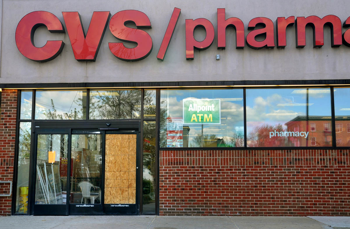
width: 300
icon-marker: large_red
Location Name: CVS Pharmacy
Incident explanation: Property damage and looting reported.
Location: 39.352242, -76.610292
Photo:
width: 300
icon-marker: large_red
Date: 4/27/2015
Location Name: Target at Mondawmin Mall
Incident explanation: Property damage reported.
Location: 39.317409, -76.656230
Photo:
width: 300
icon-marker: large_red
Location Name: Target at Mondawmin Mall
Incident explanation: Property damage reported.
Location: 39.317409, -76.656230
Photo:
width: 300
icon-marker: large_red
Date: 4/27/2015
Location Name: Deals at Mondawmin Mall
Incident explanation: Property damage reported.
Location: 39.316701, -76.658397
Photo:
width: 300
icon-marker: large_red
Location Name: Deals at Mondawmin Mall
Incident explanation: Property damage reported.
Location: 39.316701, -76.658397
Photo:
width: 300
icon-marker: large_red
Date: 4/27/2015
Location Name: First Star Grocery
Incident explanation: Property damage reported.
(AP Photo/Evan Vucci)
Location: 39.309883, -76.643117
Photo:
width: 300
icon-marker: large_red
Location Name: First Star Grocery
Incident explanation: Property damage reported.
(AP Photo/Evan Vucci)
Location: 39.309883, -76.643117
Photo:
width: 300
icon-marker: large_red
Date: 4/28/2015
Location Name: North and Pennsylvania avenues
Incident explanation: Baltimore's new weeklong, citywide curfew was met by a small, defiant group of people facing off with helmeted police officers in West Baltimore.
Location: 39.310252, -76.642303
Photo:
width: 300
icon-marker: large_yellow
Location Name: North and Pennsylvania avenues
Incident explanation: Baltimore's new weeklong, citywide curfew was met by a small, defiant group of people facing off with helmeted police officers in West Baltimore.
Location: 39.310252, -76.642303
Photo:
width: 300
icon-marker: large_yellow
Date: 4/27/2015
Location Name: Law Offices of Roland Brockmeyer
Incident explanation: Property damage reported.
Location: 39.296354, -76.614254
Photo:
width: 300
icon-marker: large_red
Location Name: Law Offices of Roland Brockmeyer
Incident explanation: Property damage reported.
Location: 39.296354, -76.614254
Photo:
width: 300
icon-marker: large_red
Date: 4-27-15
Location Name: Jackson Hewitt
Incident explanation: Property damage reported.
Location: 39.282387, -76.654617
Photo:
width: 300
icon-marker: large_red
Location Name: Jackson Hewitt
Incident explanation: Property damage reported.
Location: 39.282387, -76.654617
Photo:
width: 300
icon-marker: large_red
Date: 4/27/2015
Location Name: Highland Jewlery
Incident explanation: Property damage reported.
Location: 39.286579, -76.571210
Photo:
width: 300
icon-marker: large_red
Location Name: Highland Jewlery
Incident explanation: Property damage reported.
Location: 39.286579, -76.571210
Photo:
width: 300
icon-marker: large_red
Date:
Location Name: Patapsco Avenue and 9th Street
Incident explanation: Shortly before 10 p.m. Tuesday, Baltimore Police reported a separate group of people throwing rocks and bricks at officers near the intersection of Patapsco Avenue and 9th Street in Brooklyn.
Location: 39.234871, -76.597705
Photo:
width: 0
icon-marker: large_yellow
Date: 4/27/2015
Location Name: Family Dollar
Incident explanation: Property damage and looting reported.
Location: 39.355037, -76.609873
Photo:
width: 300
icon-marker: large_red
Location Name: Family Dollar
Incident explanation: Property damage and looting reported.
Location: 39.355037, -76.609873
Photo:
width: 300
icon-marker: large_red
Date: 4/27/2015
Location Name: Boost Mobile
Incident explanation: Property damage and looting reported.
Location: 39.356053, -76.609936
Photo: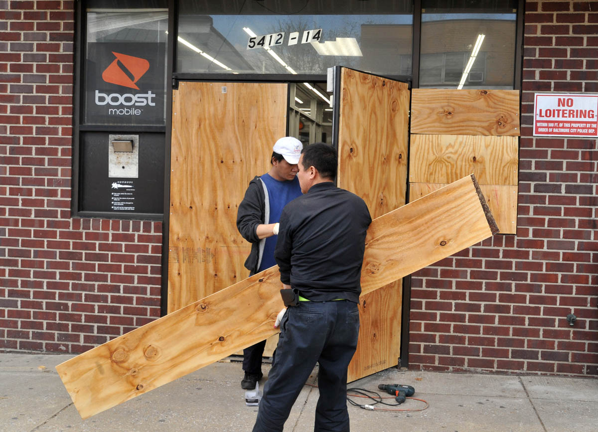
width: 300
icon-marker: large_red
Location Name: Boost Mobile
Incident explanation: Property damage and looting reported.
Location: 39.356053, -76.609936
Photo:
width: 300
icon-marker: large_red
Date: 4/27/2015
Location Name: ACE Cash Express
Incident explanation: Property damage and looting reported.
Location: 39.356080, -76.610070
Photo: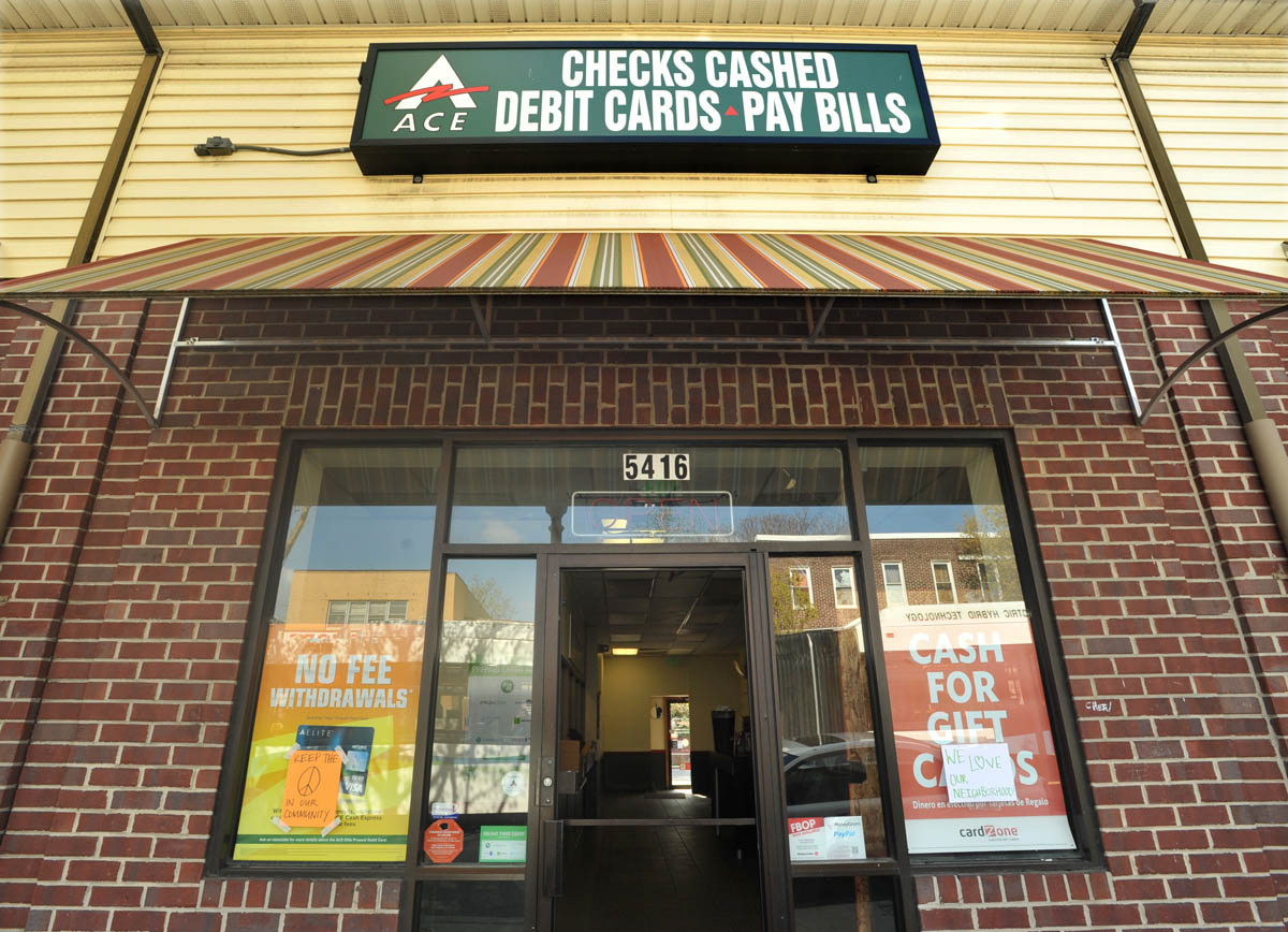
width: 300
icon-marker: large_red
Location Name: ACE Cash Express
Incident explanation: Property damage and looting reported.
Location: 39.356080, -76.610070
Photo:
width: 300
icon-marker: large_red
Date: 4/27/2015
Location Name: Boost Mobile
Incident explanation: Property damage and looting reported.
Location: 39.359036, -76.595513
Photo:
width: 300
icon-marker: large_red
Location Name: Boost Mobile
Incident explanation: Property damage and looting reported.
Location: 39.359036, -76.595513
Photo:
width: 300
icon-marker: large_red
Date: 4-27-15
Location Name: Shoe City
Incident explanation: Property damage reported.
Location: 39.281706, -76.655014
Photo:
width: 300
icon-marker: large_red
Location Name: Shoe City
Incident explanation: Property damage reported.
Location: 39.281706, -76.655014
Photo:
width: 300
icon-marker: large_red
Date: 4-27-15
Location Name: CVS Pharmacy
Incident explanation: Property damage and looting reported.
Location: 39.293231, -76.659310
Photo:
width: 300
icon-marker: large_red
Location Name: CVS Pharmacy
Incident explanation: Property damage and looting reported.
Location: 39.293231, -76.659310
Photo:
width: 300
icon-marker: large_red
Date: 4-27-15
Location Name: Rainbow clothing store
Incident explanation: Property damage reported.
Location: 39.281799, -76.654987
Photo:
width: 300
icon-marker: large_red
Location Name: Rainbow clothing store
Incident explanation: Property damage reported.
Location: 39.281799, -76.654987
Photo:
width: 300
icon-marker: large_red
Date: 4-27-15
Location Name: Dollar Tree
Incident explanation: Property damage reported.
Location: 39.281301, -76.654732
Photo:
width: 300
icon-marker: large_red
Location Name: Dollar Tree
Incident explanation: Property damage reported.
Location: 39.281301, -76.654732
Photo:
width: 300
icon-marker: large_red
Date: 4-27-15
Location Name: Rite-Aid
Incident explanation: Property damage reported.
Location: 39.283411, -76.653710
Photo:
width: 300
icon-marker: large_red
Location Name: Rite-Aid
Incident explanation: Property damage reported.
Location: 39.283411, -76.653710
Photo:
width: 300
icon-marker: large_red
Date: 4-27-15
Location Name: Penn North Minimart
Incident explanation: Property damage and looting reported.
Location: 39.310255, -76.642726
Photo:
width: 300
icon-marker: large_red
Location Name: Penn North Minimart
Incident explanation: Property damage and looting reported.
Location: 39.310255, -76.642726
Photo:
width: 300
icon-marker: large_red
Date: 4-27-15
Location Name: DTLR
Incident explanation: Property damage reported.
Location: 39.304971, -76.636172
Photo:
width: 300
icon-marker: large_red
Location Name: DTLR
Incident explanation: Property damage reported.
Location: 39.304971, -76.636172
Photo:
width: 300
icon-marker: large_red
Date: 4-27-15
Location Name: Lexington Pharmacy
Incident explanation: Property damage reported.
Location: 39.289332, -76.619369
Photo:
width: 300
icon-marker: large_red
Location Name: Lexington Pharmacy
Incident explanation: Property damage reported.
Location: 39.289332, -76.619369
Photo:
width: 300
icon-marker: large_red