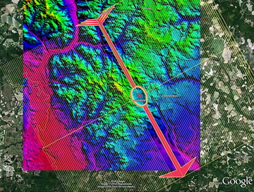
Click on the image to retrieve the LiDAR and DEM hsv-shaded Elevation Maps for visualization in Google Earth Application.
 | Arrival Bearing: 111.78º Altitude: 20 Meters |
Carolina Bay Survey
Click on the image to retrieve the LiDAR and DEM hsv-shaded Elevation Maps for visualization in Google Earth Application.
 | Arrival Bearing: 111.10º Altitude: 27 Meters |
Carolina Bay Survey
Click on the image to retrieve the LiDAR and DEM hsv-shaded Elevation Maps for visualization in Google Earth Application.
 | Arrival Bearing: 121.20º Altitude: 29.6 Meters |
Carolina Bay Survey
Click on the image to retrieve the LiDAR and DEM hsv-shaded Elevation Maps for visualization in Google Earth Application.
 | Arrival Bearing: 121.96º Altitude: 28 Meters |
Carolina Bay Survey
Click on the image to retrieve the LiDAR and DEM hsv-shaded Elevation Maps for visualization in Google Earth Application.
 | Arrival Bearing: 114.72º Altitude: 8 Meters |
Carolina Bay Survey
Click on the image to retrieve the LiDAR and DEM hsv-shaded Elevation Maps for visualization in Google Earth Application.
 | Arrival Bearing: 116.11º Altitude: 36 Meters |
Carolina Bay Survey
Click on the image to retrieve the LiDAR and DEM hsv-shaded Elevation Maps for visualization in Google Earth Application.
 | Arrival Bearing: 119.84º Altitude: 30 Meters |
Carolina Bay Survey
Click on the image to retrieve the LiDAR and DEM hsv-shaded Elevation Maps for visualization in Google Earth Application.
 | Arrival Bearing: 122.05º Altitude: 8 Meters |
Carolina Bay Survey
Click on the image to retrieve the LiDAR and DEM hsv-shaded Elevation Maps for visualization in Google Earth Application.
 | Arrival Bearing: 123.99º Altitude: 11 Meters |
Carolina Bay Survey
Click on the image to retrieve the LiDAR and DEM hsv-shaded Elevation Maps for visualization in Google Earth Application.
 | Arrival Bearing: 124.13º Altitude: 23 Meters |
Carolina Bay Survey
Click on the image to retrieve the LiDAR and DEM hsv-shaded Elevation Maps for visualization in Google Earth Application.
 | Arrival Bearing: 119.54º Altitude: 5 Meters |
Carolina Bay Survey
Click on the image to retrieve the LiDAR and DEM hsv-shaded Elevation Maps for visualization in Google Earth Application.
 | Arrival Bearing: 119.91º Altitude: 20 Meters |
Carolina Bay Survey
Click on the image to retrieve the LiDAR and DEM hsv-shaded Elevation Maps for visualization in Google Earth Application.
 | Arrival Bearing: 121.32º Altitude: 16 Meters |
Carolina Bay Survey
Click on the image to retrieve the LiDAR and DEM hsv-shaded Elevation Maps for visualization in Google Earth Application.
 | Arrival Bearing: 122.30º Altitude: 17 Meters |
Carolina Bay Survey
Click on the image to retrieve the LiDAR and DEM hsv-shaded Elevation Maps for visualization in Google Earth Application.
 | Arrival Bearing: 122.07º Altitude: 1 Meters |
Carolina Bay Survey
Click on the image to retrieve the LiDAR and DEM hsv-shaded Elevation Maps for visualization in Google Earth Application.
 | Arrival Bearing: 121.01º Altitude: 8.2 Meters |
Carolina Bay Survey
Click on the image to retrieve the LiDAR and DEM hsv-shaded Elevation Maps for visualization in Google Earth Application.
 | Arrival Bearing: 125.38º Altitude: 12 Meters |
Carolina Bay Survey
Click on the image to retrieve the LiDAR and DEM hsv-shaded Elevation Maps for visualization in Google Earth Application.
 | Arrival Bearing: 120.53º Altitude: 7.1 Meters |
Carolina Bay Survey
Click on the image to retrieve the LiDAR and DEM hsv-shaded Elevation Maps for visualization in Google Earth Application.
 | Arrival Bearing: 117.31º Altitude: 0.6 Meters |
Carolina Bay Survey
Click on the image to retrieve the LiDAR and DEM hsv-shaded Elevation Maps for visualization in Google Earth Application.
 | Arrival Bearing: 118.36º Altitude: 0 Meters |
Carolina Bay Survey
Click on the image to retrieve the LiDAR and DEM hsv-shaded Elevation Maps for visualization in Google Earth Application.
 | Arrival Bearing: 120.85º Altitude: 1 Meters |
Carolina Bay Survey
Click on the image to retrieve the LiDAR and DEM hsv-shaded Elevation Maps for visualization in Google Earth Application.
 | Arrival Bearing: 122.39º Altitude: 11 Meters |
Carolina Bay Survey
Click on the image to retrieve the LiDAR and DEM hsv-shaded Elevation Maps for visualization in Google Earth Application.
 | Arrival Bearing: 124.10º Altitude: 9 Meters |
Carolina Bay Survey
Click on the image to retrieve the LiDAR and DEM hsv-shaded Elevation Maps for visualization in Google Earth Application.
 | Arrival Bearing: 122.37º Altitude: 0.8 Meters |
Carolina Bay Survey
Click on the image to retrieve the LiDAR and DEM hsv-shaded Elevation Maps for visualization in Google Earth Application.
 | Arrival Bearing: 128.20º Altitude: 3 Meters |
Carolina Bay Survey
Click on the image to retrieve the LiDAR and DEM hsv-shaded Elevation Maps for visualization in Google Earth Application.
 | Arrival Bearing: 124.59º Altitude: 3 Meters |
Carolina Bay Survey
Click on the image to retrieve the LiDAR and DEM hsv-shaded Elevation Maps for visualization in Google Earth Application.
 | Arrival Bearing: 126.25º Altitude: 0 Meters |
Carolina Bay Survey
Click on the image to retrieve the LiDAR and DEM hsv-shaded Elevation Maps for visualization in Google Earth Application.
 | Arrival Bearing: 129.13º Altitude: 103.2 Meters |
Carolina Bay Survey
Click on the image to retrieve the LiDAR and DEM hsv-shaded Elevation Maps for visualization in Google Earth Application.
 | Arrival Bearing: 128.97º Altitude: 14 Meters |
Carolina Bay Survey
Click on the image to retrieve the LiDAR and DEM hsv-shaded Elevation Maps for visualization in Google Earth Application.
 | Arrival Bearing: 129.47º Altitude: 0 Meters |
Carolina Bay Survey
Click on the image to retrieve the LiDAR and DEM hsv-shaded Elevation Maps for visualization in Google Earth Application.
 | Arrival Bearing: 131.74º Altitude: 4 Meters |
Carolina Bay Survey
Click on the image to retrieve the LiDAR and DEM hsv-shaded Elevation Maps for visualization in Google Earth Application.
 | Arrival Bearing: 129.34º Altitude: 0 Meters |
Carolina Bay Survey
Click on the image to retrieve the LiDAR and DEM hsv-shaded Elevation Maps for visualization in Google Earth Application.
 | Arrival Bearing: 130.85º Altitude: 4 Meters |
Carolina Bay Survey
Click on the image to retrieve the LiDAR and DEM hsv-shaded Elevation Maps for visualization in Google Earth Application.
 | Arrival Bearing: 125.87º Altitude: 11 Meters |
Carolina Bay Survey
Click on the image to retrieve the LiDAR and DEM hsv-shaded Elevation Maps for visualization in Google Earth Application.
 | Arrival Bearing: 126.22º Altitude: 3 Meters |
Carolina Bay Survey
Click on the image to retrieve the LiDAR and DEM hsv-shaded Elevation Maps for visualization in Google Earth Application.
 | Arrival Bearing: 129.90º Altitude: 3 Meters |
Carolina Bay Survey
Click on the image to retrieve the LiDAR and DEM hsv-shaded Elevation Maps for visualization in Google Earth Application.
 | Arrival Bearing: 125.43º Altitude: 3 Meters |
Carolina Bay Survey
Click on the image to retrieve the LiDAR and DEM hsv-shaded Elevation Maps for visualization in Google Earth Application.
 | Arrival Bearing: 129.44º Altitude: 14.9 Meters |
Carolina Bay Survey
Click on the image to retrieve the LiDAR and DEM hsv-shaded Elevation Maps for visualization in Google Earth Application.
 | Arrival Bearing: 127.12º Altitude: 5 Meters |
Carolina Bay Survey
Click on the image to retrieve the LiDAR and DEM hsv-shaded Elevation Maps for visualization in Google Earth Application.
 | Arrival Bearing: 132.44º Altitude: 59 Meters |
Carolina Bay Survey
Click on the image to retrieve the LiDAR and DEM hsv-shaded Elevation Maps for visualization in Google Earth Application.
 | Arrival Bearing: 131.80º Altitude: 10 Meters |
Carolina Bay Survey
Click on the image to retrieve the LiDAR and DEM hsv-shaded Elevation Maps for visualization in Google Earth Application.
 | Arrival Bearing: 136.20º Altitude: 8 Meters |
Carolina Bay Survey
Click on the image to retrieve the LiDAR and DEM hsv-shaded Elevation Maps for visualization in Google Earth Application.
 | Arrival Bearing: 129.53º Altitude: 16 Meters |
Carolina Bay Survey
Click on the image to retrieve the LiDAR and DEM hsv-shaded Elevation Maps for visualization in Google Earth Application.
 | Arrival Bearing: 131.85º Altitude: 30.5 Meters |
Carolina Bay Survey
Click on the image to retrieve the LiDAR and DEM hsv-shaded Elevation Maps for visualization in Google Earth Application.
 | Arrival Bearing: 133.76º Altitude: 17 Meters |
Carolina Bay Survey
Click on the image to retrieve the LiDAR and DEM hsv-shaded Elevation Maps for visualization in Google Earth Application.
 | Arrival Bearing: 130.89º Altitude: 14 Meters |
Carolina Bay Survey
Click on the image to retrieve the LiDAR and DEM hsv-shaded Elevation Maps for visualization in Google Earth Application.
 | Arrival Bearing: 132.20º Altitude: 32.8 Meters |
Carolina Bay Survey
Click on the image to retrieve the LiDAR and DEM hsv-shaded Elevation Maps for visualization in Google Earth Application.
 | Arrival Bearing: 131.00º Altitude: 34 Meters |
Carolina Bay Survey
Click on the image to retrieve the LiDAR and DEM hsv-shaded Elevation Maps for visualization in Google Earth Application.
 | Arrival Bearing: 132.12º Altitude: 49 Meters |
Carolina Bay Survey
Click on the image to retrieve the LiDAR and DEM hsv-shaded Elevation Maps for visualization in Google Earth Application.
 | Arrival Bearing: 128.78º Altitude: 53.8 Meters |
Carolina Bay Survey
Click on the image to retrieve the LiDAR and DEM hsv-shaded Elevation Maps for visualization in Google Earth Application.
 | Arrival Bearing: 130.10º Altitude: 54 Meters |
Carolina Bay Survey
Click on the image to retrieve the LiDAR and DEM hsv-shaded Elevation Maps for visualization in Google Earth Application.
 | Arrival Bearing: 132.60º Altitude: 47 Meters |
Carolina Bay Survey
Click on the image to retrieve the LiDAR and DEM hsv-shaded Elevation Maps for visualization in Google Earth Application.
 | Arrival Bearing: 130.57º Altitude: 76 Meters |
Carolina Bay Survey
Click on the image to retrieve the LiDAR and DEM hsv-shaded Elevation Maps for visualization in Google Earth Application.
 | Arrival Bearing: 132.69º Altitude: 44.2 Meters |
Carolina Bay Survey
Click on the image to retrieve the LiDAR and DEM hsv-shaded Elevation Maps for visualization in Google Earth Application.
 | Arrival Bearing: 130.89º Altitude: 16.2 Meters |
Carolina Bay Survey
Click on the image to retrieve the LiDAR and DEM hsv-shaded Elevation Maps for visualization in Google Earth Application.
 | Arrival Bearing: 138.31º Altitude: 60 Meters |
Carolina Bay Survey
Click on the image to retrieve the LiDAR and DEM hsv-shaded Elevation Maps for visualization in Google Earth Application.
 | Arrival Bearing: 140.80º Altitude: 70.1 Meters |
Carolina Bay Survey
Click on the image to retrieve the LiDAR and DEM hsv-shaded Elevation Maps for visualization in Google Earth Application.
 | Arrival Bearing: 137.01º Altitude: 65 Meters |
Carolina Bay Survey
Click on the image to retrieve the LiDAR and DEM hsv-shaded Elevation Maps for visualization in Google Earth Application.
 | Arrival Bearing: 138.47º Altitude: 47 Meters |
Carolina Bay Survey
Click on the image to retrieve the LiDAR and DEM hsv-shaded Elevation Maps for visualization in Google Earth Application.
 | Arrival Bearing: 134.23º Altitude: 37 Meters |
Carolina Bay Survey
Click on the image to retrieve the LiDAR and DEM hsv-shaded Elevation Maps for visualization in Google Earth Application.
 | Arrival Bearing: 136.48º Altitude: 10 Meters |
Carolina Bay Survey
Click on the image to retrieve the LiDAR and DEM hsv-shaded Elevation Maps for visualization in Google Earth Application.
 | Arrival Bearing: 132.23º Altitude: 60 Meters |
Carolina Bay Survey
Click on the image to retrieve the LiDAR and DEM hsv-shaded Elevation Maps for visualization in Google Earth Application.
 | Arrival Bearing: 132.10º Altitude: 49.5 Meters |
Carolina Bay Survey
Click on the image to retrieve the LiDAR and DEM hsv-shaded Elevation Maps for visualization in Google Earth Application.
 | Arrival Bearing: 138.10º Altitude: 17 Meters |
Carolina Bay Survey
Click on the image to retrieve the LiDAR and DEM hsv-shaded Elevation Maps for visualization in Google Earth Application.
 | Arrival Bearing: 136.41º Altitude: 54 Meters |
Carolina Bay Survey
Click on the image to retrieve the LiDAR and DEM hsv-shaded Elevation Maps for visualization in Google Earth Application.
 | Arrival Bearing: 134.13º Altitude: 23 Meters |
Carolina Bay Survey
Click on the image to retrieve the LiDAR and DEM hsv-shaded Elevation Maps for visualization in Google Earth Application.
 | Arrival Bearing: 130.46º Altitude: 10.7 Meters |
Carolina Bay Survey
Click on the image to retrieve the LiDAR and DEM hsv-shaded Elevation Maps for visualization in Google Earth Application.
 | Arrival Bearing: 138.35º Altitude: 30 Meters |
Carolina Bay Survey
Click on the image to retrieve the LiDAR and DEM hsv-shaded Elevation Maps for visualization in Google Earth Application.
 | Arrival Bearing: 134.65º Altitude: 20 Meters |
Carolina Bay Survey
Click on the image to retrieve the LiDAR and DEM hsv-shaded Elevation Maps for visualization in Google Earth Application.
 | Arrival Bearing: 132.04º Altitude: 39 Meters |
Carolina Bay Survey
Click on the image to retrieve the LiDAR and DEM hsv-shaded Elevation Maps for visualization in Google Earth Application.
 | Arrival Bearing: 134.20º Altitude: 38 Meters |
Carolina Bay Survey
Click on the image to retrieve the LiDAR and DEM hsv-shaded Elevation Maps for visualization in Google Earth Application.
 | Arrival Bearing: 134.13º Altitude: 33 Meters |
Carolina Bay Survey
Click on the image to retrieve the LiDAR and DEM hsv-shaded Elevation Maps for visualization in Google Earth Application.
 | Arrival Bearing: 137.40º Altitude: 28.7 Meters |
Carolina Bay Survey
Click on the image to retrieve the LiDAR and DEM hsv-shaded Elevation Maps for visualization in Google Earth Application.
 | Arrival Bearing: 130.46º Altitude: 13 Meters |
Carolina Bay Survey
Click on the image to retrieve the LiDAR and DEM hsv-shaded Elevation Maps for visualization in Google Earth Application.
 | Arrival Bearing: 137.71º Altitude: 44.3 Meters |
Carolina Bay Survey
Click on the image to retrieve the LiDAR and DEM hsv-shaded Elevation Maps for visualization in Google Earth Application.
 | Arrival Bearing: 135.52º Altitude: 40 Meters |
Carolina Bay Survey
Click on the image to retrieve the LiDAR and DEM hsv-shaded Elevation Maps for visualization in Google Earth Application.
 | Arrival Bearing: 139.20º Altitude: 72 Meters |
Carolina Bay Survey
Click on the image to retrieve the LiDAR and DEM hsv-shaded Elevation Maps for visualization in Google Earth Application.
 | Arrival Bearing: 139.05º Altitude: 16 Meters |
Carolina Bay Survey
Click on the image to retrieve the LiDAR and DEM hsv-shaded Elevation Maps for visualization in Google Earth Application.
 | Arrival Bearing: 134.02º Altitude: 54.5 Meters |
Carolina Bay Survey
Click on the image to retrieve the LiDAR and DEM hsv-shaded Elevation Maps for visualization in Google Earth Application.
 | Arrival Bearing: 132.85º Altitude: 48.6 Meters |
Carolina Bay Survey
Click on the image to retrieve the LiDAR and DEM hsv-shaded Elevation Maps for visualization in Google Earth Application.
 | Arrival Bearing: 138.32º Altitude: 33 Meters |
Carolina Bay Survey
Click on the image to retrieve the LiDAR and DEM hsv-shaded Elevation Maps for visualization in Google Earth Application.
 | Arrival Bearing: 134.80º Altitude: 18 Meters |
Carolina Bay Survey
Click on the image to retrieve the LiDAR and DEM hsv-shaded Elevation Maps for visualization in Google Earth Application.
 | Arrival Bearing: 134.86º Altitude: 65 Meters |
Carolina Bay Survey
Click on the image to retrieve the LiDAR and DEM hsv-shaded Elevation Maps for visualization in Google Earth Application.
 | Arrival Bearing: 137.61º Altitude: 61 Meters |
Carolina Bay Survey
Click on the image to retrieve the LiDAR and DEM hsv-shaded Elevation Maps for visualization in Google Earth Application.
 | Arrival Bearing: 140.23º Altitude: 22 Meters |
Carolina Bay Survey
Click on the image to retrieve the LiDAR and DEM hsv-shaded Elevation Maps for visualization in Google Earth Application.
 | Arrival Bearing: 138.70º Altitude: 29 Meters |
Carolina Bay Survey
Click on the image to retrieve the LiDAR and DEM hsv-shaded Elevation Maps for visualization in Google Earth Application.
 | Arrival Bearing: 139.19º Altitude: 31 Meters |
Carolina Bay Survey
Click on the image to retrieve the LiDAR and DEM hsv-shaded Elevation Maps for visualization in Google Earth Application.
 | Arrival Bearing: 133.27º Altitude: 35 Meters |
Carolina Bay Survey
Click on the image to retrieve the LiDAR and DEM hsv-shaded Elevation Maps for visualization in Google Earth Application.
 | Arrival Bearing: 137.52º Altitude: 74 Meters |
Carolina Bay Survey
Click on the image to retrieve the LiDAR and DEM hsv-shaded Elevation Maps for visualization in Google Earth Application.
 | Arrival Bearing: 135.69º Altitude: 62.7 Meters |
Carolina Bay Survey
Click on the image to retrieve the LiDAR and DEM hsv-shaded Elevation Maps for visualization in Google Earth Application.
 | Arrival Bearing: 141.12º Altitude: 53 Meters |
Carolina Bay Survey
Click on the image to retrieve the LiDAR and DEM hsv-shaded Elevation Maps for visualization in Google Earth Application.
 | Arrival Bearing: 137.43º Altitude: 13 Meters |
Carolina Bay Survey
Click on the image to retrieve the LiDAR and DEM hsv-shaded Elevation Maps for visualization in Google Earth Application.
 | Arrival Bearing: 136.87º Altitude: 74 Meters |
Carolina Bay Survey
Click on the image to retrieve the LiDAR and DEM hsv-shaded Elevation Maps for visualization in Google Earth Application.
 | Arrival Bearing: 140.12º Altitude: 40.4 Meters |
Carolina Bay Survey
Click on the image to retrieve the LiDAR and DEM hsv-shaded Elevation Maps for visualization in Google Earth Application.
 | Arrival Bearing: 142.50º Altitude: 42 Meters |
Carolina Bay Survey
Click on the image to retrieve the LiDAR and DEM hsv-shaded Elevation Maps for visualization in Google Earth Application.
 | Arrival Bearing: 135.04º Altitude: 63 Meters |
Carolina Bay Survey
Click on the image to retrieve the LiDAR and DEM hsv-shaded Elevation Maps for visualization in Google Earth Application.
 | Arrival Bearing: 140.90º Altitude: 34 Meters |
Carolina Bay Survey
Click on the image to retrieve the LiDAR and DEM hsv-shaded Elevation Maps for visualization in Google Earth Application.
 | Arrival Bearing: 137.00º Altitude: 41 Meters |
Carolina Bay Survey
Click on the image to retrieve the LiDAR and DEM hsv-shaded Elevation Maps for visualization in Google Earth Application.
 | Arrival Bearing: 142.71º Altitude: 28.8 Meters |
Carolina Bay Survey
Click on the image to retrieve the LiDAR and DEM hsv-shaded Elevation Maps for visualization in Google Earth Application.
 | Arrival Bearing: 142.27º Altitude: 46 Meters |
Carolina Bay Survey
Click on the image to retrieve the LiDAR and DEM hsv-shaded Elevation Maps for visualization in Google Earth Application.
 | Arrival Bearing: 139.18º Altitude: 78 Meters |
Carolina Bay Survey
Click on the image to retrieve the LiDAR and DEM hsv-shaded Elevation Maps for visualization in Google Earth Application.
 | Arrival Bearing: 139.96º Altitude: 58 Meters |
Carolina Bay Survey
Click on the image to retrieve the LiDAR and DEM hsv-shaded Elevation Maps for visualization in Google Earth Application.
 | Arrival Bearing: 144.64º Altitude: 5 Meters |
Carolina Bay Survey
Click on the image to retrieve the LiDAR and DEM hsv-shaded Elevation Maps for visualization in Google Earth Application.
 | Arrival Bearing: 141.41º Altitude: 37 Meters |
Carolina Bay Survey
Click on the image to retrieve the LiDAR and DEM hsv-shaded Elevation Maps for visualization in Google Earth Application.
 | Arrival Bearing: 141.40º Altitude: 39 Meters |
Carolina Bay Survey
Click on the image to retrieve the LiDAR and DEM hsv-shaded Elevation Maps for visualization in Google Earth Application.
 | Arrival Bearing: 141.87º Altitude: 12 Meters |
Carolina Bay Survey
Click on the image to retrieve the LiDAR and DEM hsv-shaded Elevation Maps for visualization in Google Earth Application.
 | Arrival Bearing: 145.36º Altitude: 100 Meters |
Carolina Bay Survey
Click on the image to retrieve the LiDAR and DEM hsv-shaded Elevation Maps for visualization in Google Earth Application.
 | Arrival Bearing: 145.38º Altitude: 94.9 Meters |
Carolina Bay Survey
Click on the image to retrieve the LiDAR and DEM hsv-shaded Elevation Maps for visualization in Google Earth Application.
 | Arrival Bearing: 141.95º Altitude: 47 Meters |
Carolina Bay Survey
Click on the image to retrieve the LiDAR and DEM hsv-shaded Elevation Maps for visualization in Google Earth Application.
 | Arrival Bearing: 145.81º Altitude: 61 Meters |
Carolina Bay Survey
Click on the image to retrieve the LiDAR and DEM hsv-shaded Elevation Maps for visualization in Google Earth Application.
 | Arrival Bearing: 140.40º Altitude: 61 Meters |
Carolina Bay Survey
Click on the image to retrieve the LiDAR and DEM hsv-shaded Elevation Maps for visualization in Google Earth Application.
 | Arrival Bearing: 138.16º Altitude: 57 Meters |
Carolina Bay Survey
Click on the image to retrieve the LiDAR and DEM hsv-shaded Elevation Maps for visualization in Google Earth Application.
 | Arrival Bearing: 146.49º Altitude: 10.7 Meters |
Carolina Bay Survey
Click on the image to retrieve the LiDAR and DEM hsv-shaded Elevation Maps for visualization in Google Earth Application.
 | Arrival Bearing: 145.85º Altitude: 19 Meters |
Carolina Bay Survey
Click on the image to retrieve the LiDAR and DEM hsv-shaded Elevation Maps for visualization in Google Earth Application.
 | Arrival Bearing: 140.82º Altitude: 10 Meters |
Carolina Bay Survey
Click on the image to retrieve the LiDAR and DEM hsv-shaded Elevation Maps for visualization in Google Earth Application.
 | Arrival Bearing: 146.31º Altitude: 50 Meters |
Carolina Bay Survey
Click on the image to retrieve the LiDAR and DEM hsv-shaded Elevation Maps for visualization in Google Earth Application.
 | Arrival Bearing: 142.68º Altitude: 24 Meters |
Carolina Bay Survey
Click on the image to retrieve the LiDAR and DEM hsv-shaded Elevation Maps for visualization in Google Earth Application.
 | Arrival Bearing: 145.82º Altitude: 18 Meters |
Carolina Bay Survey
Click on the image to retrieve the LiDAR and DEM hsv-shaded Elevation Maps for visualization in Google Earth Application.
 | Arrival Bearing: 144.41º Altitude: 69 Meters |
Carolina Bay Survey
Click on the image to retrieve the LiDAR and DEM hsv-shaded Elevation Maps for visualization in Google Earth Application.
 | Arrival Bearing: 141.82º Altitude: 34 Meters |
Carolina Bay Survey
Click on the image to retrieve the LiDAR and DEM hsv-shaded Elevation Maps for visualization in Google Earth Application.
 | Arrival Bearing: 144.65º Altitude: 14 Meters |
Carolina Bay Survey
Click on the image to retrieve the LiDAR and DEM hsv-shaded Elevation Maps for visualization in Google Earth Application.
 | Arrival Bearing: 147.51º Altitude: 141 Meters |
Carolina Bay Survey
Click on the image to retrieve the LiDAR and DEM hsv-shaded Elevation Maps for visualization in Google Earth Application.
 | Arrival Bearing: 147.27º Altitude: 118.7 Meters |
Carolina Bay Survey
Click on the image to retrieve the LiDAR and DEM hsv-shaded Elevation Maps for visualization in Google Earth Application.
 | Arrival Bearing: 145.43º Altitude: 25 Meters |
Carolina Bay Survey
Click on the image to retrieve the LiDAR and DEM hsv-shaded Elevation Maps for visualization in Google Earth Application.
 | Arrival Bearing: 146.50º Altitude: 21 Meters |
Carolina Bay Survey
Click on the image to retrieve the LiDAR and DEM hsv-shaded Elevation Maps for visualization in Google Earth Application.
 | Arrival Bearing: 149.29º Altitude: 30.6 Meters |
Carolina Bay Survey
Click on the image to retrieve the LiDAR and DEM hsv-shaded Elevation Maps for visualization in Google Earth Application.
 | Arrival Bearing: 146.86º Altitude: 37 Meters |
Carolina Bay Survey
Click on the image to retrieve the LiDAR and DEM hsv-shaded Elevation Maps for visualization in Google Earth Application.
 | Arrival Bearing: 143.67º Altitude: 39 Meters |
Carolina Bay Survey
Click on the image to retrieve the LiDAR and DEM hsv-shaded Elevation Maps for visualization in Google Earth Application.
 | Arrival Bearing: 143.67º Altitude: 56 Meters |
Carolina Bay Survey
Click on the image to retrieve the LiDAR and DEM hsv-shaded Elevation Maps for visualization in Google Earth Application.
 | Arrival Bearing: 148.10º Altitude: 50 Meters |
Carolina Bay Survey
Click on the image to retrieve the LiDAR and DEM hsv-shaded Elevation Maps for visualization in Google Earth Application.
 | Arrival Bearing: 145.01º Altitude: 41.4 Meters |
Carolina Bay Survey
Click on the image to retrieve the LiDAR and DEM hsv-shaded Elevation Maps for visualization in Google Earth Application.
 | Arrival Bearing: 151.82º Altitude: 56 Meters |
Carolina Bay Survey
Click on the image to retrieve the LiDAR and DEM hsv-shaded Elevation Maps for visualization in Google Earth Application.
 | Arrival Bearing: 150.38º Altitude: 35 Meters |
Carolina Bay Survey
Click on the image to retrieve the LiDAR and DEM hsv-shaded Elevation Maps for visualization in Google Earth Application.
 | Arrival Bearing: 146.27º Altitude: 37 Meters |
Carolina Bay Survey
Click on the image to retrieve the LiDAR and DEM hsv-shaded Elevation Maps for visualization in Google Earth Application.
 | Arrival Bearing: 151.50º Altitude: 48 Meters |
Carolina Bay Survey
Click on the image to retrieve the LiDAR and DEM hsv-shaded Elevation Maps for visualization in Google Earth Application.
 | Arrival Bearing: 149.96º Altitude: 40 Meters |
Carolina Bay Survey
Click on the image to retrieve the LiDAR and DEM hsv-shaded Elevation Maps for visualization in Google Earth Application.
 | Arrival Bearing: 149.75º Altitude: 88.1 Meters |
Carolina Bay Survey
Click on the image to retrieve the LiDAR and DEM hsv-shaded Elevation Maps for visualization in Google Earth Application.
 | Arrival Bearing: 149.83º Altitude: 39.1 Meters |
Carolina Bay Survey
Click on the image to retrieve the LiDAR and DEM hsv-shaded Elevation Maps for visualization in Google Earth Application.
 | Arrival Bearing: 151.56º Altitude: 63 Meters |
Carolina Bay Survey
Click on the image to retrieve the LiDAR and DEM hsv-shaded Elevation Maps for visualization in Google Earth Application.
 | Arrival Bearing: 150.30º Altitude: 50 Meters |
Carolina Bay Survey
Click on the image to retrieve the LiDAR and DEM hsv-shaded Elevation Maps for visualization in Google Earth Application.
 | Arrival Bearing: 153.59º Altitude: 75 Meters |
Carolina Bay Survey
Click on the image to retrieve the LiDAR and DEM hsv-shaded Elevation Maps for visualization in Google Earth Application.
 | Arrival Bearing: 152.26º Altitude: 48 Meters |
Carolina Bay Survey
Click on the image to retrieve the LiDAR and DEM hsv-shaded Elevation Maps for visualization in Google Earth Application.
 | Arrival Bearing: 151.21º Altitude: 32 Meters |
Carolina Bay Survey
Click on the image to retrieve the LiDAR and DEM hsv-shaded Elevation Maps for visualization in Google Earth Application.
 | Arrival Bearing: 154.80º Altitude: 86 Meters |
Carolina Bay Survey
Click on the image to retrieve the LiDAR and DEM hsv-shaded Elevation Maps for visualization in Google Earth Application.
 | Arrival Bearing: 147.20º Altitude: 55 Meters |
Carolina Bay Survey
Click on the image to retrieve the LiDAR and DEM hsv-shaded Elevation Maps for visualization in Google Earth Application.
 | Arrival Bearing: 153.85º Altitude: 78 Meters |
Carolina Bay Survey
Click on the image to retrieve the LiDAR and DEM hsv-shaded Elevation Maps for visualization in Google Earth Application.
 | Arrival Bearing: 151.13º Altitude: 56 Meters |
Carolina Bay Survey
Click on the image to retrieve the LiDAR and DEM hsv-shaded Elevation Maps for visualization in Google Earth Application.
 | Arrival Bearing: 152.74º Altitude: 32 Meters |
Carolina Bay Survey
Click on the image to retrieve the LiDAR and DEM hsv-shaded Elevation Maps for visualization in Google Earth Application.
 | Arrival Bearing: 152.93º Altitude: 46 Meters |
Carolina Bay Survey
Click on the image to retrieve the LiDAR and DEM hsv-shaded Elevation Maps for visualization in Google Earth Application.
 | Arrival Bearing: 154.78º Altitude: 24 Meters |
Carolina Bay Survey
Click on the image to retrieve the LiDAR and DEM hsv-shaded Elevation Maps for visualization in Google Earth Application.
 | Arrival Bearing: 148.70º Altitude: 130 Meters |
Carolina Bay Survey
Click on the image to retrieve the LiDAR and DEM hsv-shaded Elevation Maps for visualization in Google Earth Application.
 | Arrival Bearing: 156.89º Altitude: 74 Meters |
Carolina Bay Survey
Click on the image to retrieve the LiDAR and DEM hsv-shaded Elevation Maps for visualization in Google Earth Application.
 | Arrival Bearing: 156.20º Altitude: 126 Meters |
Carolina Bay Survey
Click on the image to retrieve the LiDAR and DEM hsv-shaded Elevation Maps for visualization in Google Earth Application.
 | Arrival Bearing: 154.96º Altitude: 49 Meters |
Carolina Bay Survey
Click on the image to retrieve the LiDAR and DEM hsv-shaded Elevation Maps for visualization in Google Earth Application.
 | Arrival Bearing: 158.02º Altitude: 98 Meters |
Carolina Bay Survey
Click on the image to retrieve the LiDAR and DEM hsv-shaded Elevation Maps for visualization in Google Earth Application.
 | Arrival Bearing: 162.33º Altitude: 169 Meters |
Carolina Bay Survey
Click on the image to retrieve the LiDAR and DEM hsv-shaded Elevation Maps for visualization in Google Earth Application.
 | Arrival Bearing: 155.29º Altitude: 65 Meters |
Carolina Bay Survey
Click on the image to retrieve the LiDAR and DEM hsv-shaded Elevation Maps for visualization in Google Earth Application.
 | Arrival Bearing: 156.80º Altitude: 76 Meters |
Carolina Bay Survey
Click on the image to retrieve the LiDAR and DEM hsv-shaded Elevation Maps for visualization in Google Earth Application.
 | Arrival Bearing: 157.96º Altitude: 127 Meters |
Carolina Bay Survey
Click on the image to retrieve the LiDAR and DEM hsv-shaded Elevation Maps for visualization in Google Earth Application.
 | Arrival Bearing: 161.03º Altitude: 95 Meters |
Carolina Bay Survey
Click on the image to retrieve the LiDAR and DEM hsv-shaded Elevation Maps for visualization in Google Earth Application.
 | Arrival Bearing: 159.78º Altitude: 59 Meters |
Carolina Bay Survey
Click on the image to retrieve the LiDAR and DEM hsv-shaded Elevation Maps for visualization in Google Earth Application.
 | Arrival Bearing: 157.79º Altitude: 72 Meters |
Carolina Bay Survey
Click on the image to retrieve the LiDAR and DEM hsv-shaded Elevation Maps for visualization in Google Earth Application.
 | Arrival Bearing: 158.91º Altitude: 71 Meters |
Carolina Bay Survey
Click on the image to retrieve the LiDAR and DEM hsv-shaded Elevation Maps for visualization in Google Earth Application.
 | Arrival Bearing: 161.68º Altitude: 104.5 Meters |
Carolina Bay Survey
Click on the image to retrieve the LiDAR and DEM hsv-shaded Elevation Maps for visualization in Google Earth Application.
 | Arrival Bearing: 159.72º Altitude: 79 Meters |
Carolina Bay Survey
Click on the image to retrieve the LiDAR and DEM hsv-shaded Elevation Maps for visualization in Google Earth Application.
 | Arrival Bearing: 163.52º Altitude: 145 Meters |
Carolina Bay Survey
Click on the image to retrieve the LiDAR and DEM hsv-shaded Elevation Maps for visualization in Google Earth Application.
 | Arrival Bearing: 160.64º Altitude: 156.5 Meters |
Carolina Bay Survey
Click on the image to retrieve the LiDAR and DEM hsv-shaded Elevation Maps for visualization in Google Earth Application.
 | Arrival Bearing: 160.63º Altitude: 149 Meters |
Carolina Bay Survey
Click on the image to retrieve the LiDAR and DEM hsv-shaded Elevation Maps for visualization in Google Earth Application.
 | Arrival Bearing: 159.20º Altitude: 115.7 Meters |
Carolina Bay Survey
Click on the image to retrieve the LiDAR and DEM hsv-shaded Elevation Maps for visualization in Google Earth Application.
 | Arrival Bearing: 164.73º Altitude: 77 Meters |
Carolina Bay Survey
Click on the image to retrieve the LiDAR and DEM hsv-shaded Elevation Maps for visualization in Google Earth Application.
 | Arrival Bearing: 166.00º Altitude: 65 Meters |
Carolina Bay Survey
Click on the image to retrieve the LiDAR and DEM hsv-shaded Elevation Maps for visualization in Google Earth Application.
 | Arrival Bearing: 163.74º Altitude: 43 Meters |
Carolina Bay Survey
Click on the image to retrieve the LiDAR and DEM hsv-shaded Elevation Maps for visualization in Google Earth Application.
 | Arrival Bearing: 161.52º Altitude: 88.6 Meters |
Carolina Bay Survey
Click on the image to retrieve the LiDAR and DEM hsv-shaded Elevation Maps for visualization in Google Earth Application.
 | Arrival Bearing: 163.38º Altitude: 87.3 Meters |
Carolina Bay Survey
Click on the image to retrieve the LiDAR and DEM hsv-shaded Elevation Maps for visualization in Google Earth Application.
 | Arrival Bearing: 162.00º Altitude: 87 Meters |
Carolina Bay Survey
Click on the image to retrieve the LiDAR and DEM hsv-shaded Elevation Maps for visualization in Google Earth Application.
 | Arrival Bearing: 163.46º Altitude: 109 Meters |
Carolina Bay Survey
Click on the image to retrieve the LiDAR and DEM hsv-shaded Elevation Maps for visualization in Google Earth Application.
 | Arrival Bearing: 169.67º Altitude: 95.6 Meters |
Carolina Bay Survey
Click on the image to retrieve the LiDAR and DEM hsv-shaded Elevation Maps for visualization in Google Earth Application.
 | Arrival Bearing: 163.31º Altitude: 118 Meters |
Carolina Bay Survey
Click on the image to retrieve the LiDAR and DEM hsv-shaded Elevation Maps for visualization in Google Earth Application.
 | Arrival Bearing: 228.75º Altitude: 944 Meters |
Carolina Bay Survey
Click on the image to retrieve the LiDAR and DEM hsv-shaded Elevation Maps for visualization in Google Earth Application.
 | Arrival Bearing: 234.79º Altitude: 548.3 Meters |
Carolina Bay Survey
Click on the image to retrieve the LiDAR and DEM hsv-shaded Elevation Maps for visualization in Google Earth Application.
 | Arrival Bearing: 234.53º Altitude: 1335 Meters |
Carolina Bay Survey
Click on the image to retrieve the LiDAR and DEM hsv-shaded Elevation Maps for visualization in Google Earth Application.
 | Arrival Bearing: 236.06º Altitude: 603 Meters |
Carolina Bay Survey
Click on the image to retrieve the LiDAR and DEM hsv-shaded Elevation Maps for visualization in Google Earth Application.
 | Arrival Bearing: 237.50º Altitude: 485 Meters |
Carolina Bay Survey
Click on the image to retrieve the LiDAR and DEM hsv-shaded Elevation Maps for visualization in Google Earth Application.
 | Arrival Bearing: 240.75º Altitude: 498.7 Meters |
Carolina Bay Survey
Click on the image to retrieve the LiDAR and DEM hsv-shaded Elevation Maps for visualization in Google Earth Application.
 | Arrival Bearing: 238.95º Altitude: 492 Meters |
Carolina Bay Survey
Click on the image to retrieve the LiDAR and DEM hsv-shaded Elevation Maps for visualization in Google Earth Application.
 | Arrival Bearing: 240.08º Altitude: 478.1 Meters |
Carolina Bay Survey
Click on the image to retrieve the LiDAR and DEM hsv-shaded Elevation Maps for visualization in Google Earth Application.
 | Arrival Bearing: 238.12º Altitude: 506.7 Meters |
Carolina Bay Survey
Click on the image to retrieve the LiDAR and DEM hsv-shaded Elevation Maps for visualization in Google Earth Application.
 | Arrival Bearing: 238.26º Altitude: 594 Meters |
Carolina Bay Survey
Click on the image to retrieve the LiDAR and DEM hsv-shaded Elevation Maps for visualization in Google Earth Application.
 | Arrival Bearing: 242.15º Altitude: 522 Meters |
Carolina Bay Survey
Click on the image to retrieve the LiDAR and DEM hsv-shaded Elevation Maps for visualization in Google Earth Application.
 | Arrival Bearing: 237.27º Altitude: 1022 Meters |
Carolina Bay Survey
Click on the image to retrieve the LiDAR and DEM hsv-shaded Elevation Maps for visualization in Google Earth Application.
 | Arrival Bearing: 242.36º Altitude: 509 Meters |
Carolina Bay Survey
Click on the image to retrieve the LiDAR and DEM hsv-shaded Elevation Maps for visualization in Google Earth Application.
 | Arrival Bearing: 236.82º Altitude: 1573 Meters |
Carolina Bay Survey
Click on the image to retrieve the LiDAR and DEM hsv-shaded Elevation Maps for visualization in Google Earth Application.
 | Arrival Bearing: 238.61º Altitude: 534 Meters |
Carolina Bay Survey
Click on the image to retrieve the LiDAR and DEM hsv-shaded Elevation Maps for visualization in Google Earth Application.
 | Arrival Bearing: 237.24º Altitude: 1140 Meters |
Carolina Bay Survey
Click on the image to retrieve the LiDAR and DEM hsv-shaded Elevation Maps for visualization in Google Earth Application.
 | Arrival Bearing: 238.46º Altitude: 632 Meters |
Carolina Bay Survey
Click on the image to retrieve the LiDAR and DEM hsv-shaded Elevation Maps for visualization in Google Earth Application.
 | Arrival Bearing: 238.95º Altitude: 524 Meters |
Carolina Bay Survey
Click on the image to retrieve the LiDAR and DEM hsv-shaded Elevation Maps for visualization in Google Earth Application.
 | Arrival Bearing: 241.07º Altitude: 550 Meters |
Carolina Bay Survey
Click on the image to retrieve the LiDAR and DEM hsv-shaded Elevation Maps for visualization in Google Earth Application.
 | Arrival Bearing: 240.10º Altitude: 541 Meters |
Carolina Bay Survey
Click on the image to retrieve the LiDAR and DEM hsv-shaded Elevation Maps for visualization in Google Earth Application.
 | Arrival Bearing: 238.92º Altitude: 627.6 Meters |
Carolina Bay Survey
Click on the image to retrieve the LiDAR and DEM hsv-shaded Elevation Maps for visualization in Google Earth Application.
 | Arrival Bearing: 242.84º Altitude: 510 Meters |
Carolina Bay Survey
Click on the image to retrieve the LiDAR and DEM hsv-shaded Elevation Maps for visualization in Google Earth Application.
 | Arrival Bearing: 241.54º Altitude: 553 Meters |
Carolina Bay Survey
Click on the image to retrieve the LiDAR and DEM hsv-shaded Elevation Maps for visualization in Google Earth Application.
 | Arrival Bearing: 236.93º Altitude: 485.7 Meters |
Carolina Bay Survey
Click on the image to retrieve the LiDAR and DEM hsv-shaded Elevation Maps for visualization in Google Earth Application.
 | Arrival Bearing: 239.15º Altitude: 710 Meters |
Carolina Bay Survey
Click on the image to retrieve the LiDAR and DEM hsv-shaded Elevation Maps for visualization in Google Earth Application.
 | Arrival Bearing: 240.41º Altitude: 672 Meters |
Carolina Bay Survey
Click on the image to retrieve the LiDAR and DEM hsv-shaded Elevation Maps for visualization in Google Earth Application.
 | Arrival Bearing: 240.80º Altitude: 657 Meters |
Carolina Bay Survey
Click on the image to retrieve the LiDAR and DEM hsv-shaded Elevation Maps for visualization in Google Earth Application.
 | Arrival Bearing: 238.18º Altitude: 623 Meters |
Carolina Bay Survey
Click on the image to retrieve the LiDAR and DEM hsv-shaded Elevation Maps for visualization in Google Earth Application.
 | Arrival Bearing: 240.95º Altitude: 623 Meters |
Carolina Bay Survey
Click on the image to retrieve the LiDAR and DEM hsv-shaded Elevation Maps for visualization in Google Earth Application.
 | Arrival Bearing: 241.86º Altitude: 594 Meters |
Carolina Bay Survey
Click on the image to retrieve the LiDAR and DEM hsv-shaded Elevation Maps for visualization in Google Earth Application.
 | Arrival Bearing: 241.92º Altitude: 464.8 Meters |
Carolina Bay Survey
Click on the image to retrieve the LiDAR and DEM hsv-shaded Elevation Maps for visualization in Google Earth Application.
 | Arrival Bearing: 245.61º Altitude: 493 Meters |
Carolina Bay Survey
Click on the image to retrieve the LiDAR and DEM hsv-shaded Elevation Maps for visualization in Google Earth Application.
 | Arrival Bearing: 240.49º Altitude: 527 Meters |
Carolina Bay Survey
Click on the image to retrieve the LiDAR and DEM hsv-shaded Elevation Maps for visualization in Google Earth Application.
 | Arrival Bearing: 240.07º Altitude: 689 Meters |
Carolina Bay Survey
Click on the image to retrieve the LiDAR and DEM hsv-shaded Elevation Maps for visualization in Google Earth Application.
 | Arrival Bearing: 240.15º Altitude: 738 Meters |
Carolina Bay Survey
Click on the image to retrieve the LiDAR and DEM hsv-shaded Elevation Maps for visualization in Google Earth Application.
 | Arrival Bearing: 243.23º Altitude: 497 Meters |
Carolina Bay Survey
Click on the image to retrieve the LiDAR and DEM hsv-shaded Elevation Maps for visualization in Google Earth Application.
 | Arrival Bearing: 237.83º Altitude: 482 Meters |
Carolina Bay Survey
Click on the image to retrieve the LiDAR and DEM hsv-shaded Elevation Maps for visualization in Google Earth Application.
 | Arrival Bearing: 239.69º Altitude: 556 Meters |
Carolina Bay Survey
Click on the image to retrieve the LiDAR and DEM hsv-shaded Elevation Maps for visualization in Google Earth Application.
 | Arrival Bearing: 240.39º Altitude: 888 Meters |
Carolina Bay Survey
Click on the image to retrieve the LiDAR and DEM hsv-shaded Elevation Maps for visualization in Google Earth Application.
 | Arrival Bearing: 238.59º Altitude: 570 Meters |
Carolina Bay Survey
Click on the image to retrieve the LiDAR and DEM hsv-shaded Elevation Maps for visualization in Google Earth Application.
 | Arrival Bearing: 241.72º Altitude: 533 Meters |
Carolina Bay Survey
Click on the image to retrieve the LiDAR and DEM hsv-shaded Elevation Maps for visualization in Google Earth Application.
 | Arrival Bearing: 241.82º Altitude: 524.1 Meters |
Carolina Bay Survey
Click on the image to retrieve the LiDAR and DEM hsv-shaded Elevation Maps for visualization in Google Earth Application.
 | Arrival Bearing: 245.53º Altitude: 558 Meters |
Carolina Bay Survey
Click on the image to retrieve the LiDAR and DEM hsv-shaded Elevation Maps for visualization in Google Earth Application.
 | Arrival Bearing: 243.48º Altitude: 516.4 Meters |
Carolina Bay Survey
Click on the image to retrieve the LiDAR and DEM hsv-shaded Elevation Maps for visualization in Google Earth Application.
 | Arrival Bearing: 241.69º Altitude: 684 Meters |
Carolina Bay Survey
Click on the image to retrieve the LiDAR and DEM hsv-shaded Elevation Maps for visualization in Google Earth Application.
 | Arrival Bearing: 243.49º Altitude: 497 Meters |
Carolina Bay Survey
Click on the image to retrieve the LiDAR and DEM hsv-shaded Elevation Maps for visualization in Google Earth Application.
 | Arrival Bearing: 242.82º Altitude: 509 Meters |
Carolina Bay Survey
Click on the image to retrieve the LiDAR and DEM hsv-shaded Elevation Maps for visualization in Google Earth Application.
 | Arrival Bearing: 244.54º Altitude: 482 Meters |
Carolina Bay Survey
Click on the image to retrieve the LiDAR and DEM hsv-shaded Elevation Maps for visualization in Google Earth Application.
 | Arrival Bearing: 244.45º Altitude: 529.5 Meters |
Carolina Bay Survey
Click on the image to retrieve the LiDAR and DEM hsv-shaded Elevation Maps for visualization in Google Earth Application.
 | Arrival Bearing: 242.54º Altitude: 723.8 Meters |
Carolina Bay Survey
Click on the image to retrieve the LiDAR and DEM hsv-shaded Elevation Maps for visualization in Google Earth Application.
 | Arrival Bearing: 243.33º Altitude: 848 Meters |
Carolina Bay Survey
Click on the image to retrieve the LiDAR and DEM hsv-shaded Elevation Maps for visualization in Google Earth Application.
 | Arrival Bearing: 240.77º Altitude: 695 Meters |
Carolina Bay Survey
Click on the image to retrieve the LiDAR and DEM hsv-shaded Elevation Maps for visualization in Google Earth Application.
 | Arrival Bearing: 249.50º Altitude: 894 Meters |
Carolina Bay Survey
Click on the image to retrieve the LiDAR and DEM hsv-shaded Elevation Maps for visualization in Google Earth Application.
 | Arrival Bearing: 245.75º Altitude: 782 Meters |
Carolina Bay Survey
Click on the image to retrieve the LiDAR and DEM hsv-shaded Elevation Maps for visualization in Google Earth Application.
 | Arrival Bearing: 250.55º Altitude: 841 Meters |
Carolina Bay Survey
Click on the image to retrieve the LiDAR and DEM hsv-shaded Elevation Maps for visualization in Google Earth Application.
 | Arrival Bearing: 245.77º Altitude: 623 Meters |
Carolina Bay Survey
Click on the image to retrieve the LiDAR and DEM hsv-shaded Elevation Maps for visualization in Google Earth Application.
 | Arrival Bearing: 250.45º Altitude: 572 Meters |
Carolina Bay Survey
Click on the image to retrieve the LiDAR and DEM hsv-shaded Elevation Maps for visualization in Google Earth Application.
 | Arrival Bearing: 141.56º Altitude: 19 Meters |
Carolina Bay Survey
Click on the image to retrieve the LiDAR and DEM hsv-shaded Elevation Maps for visualization in Google Earth Application.
 | Arrival Bearing: 140.25º Altitude: 57 Meters |
Carolina Bay Survey
Click on the image to retrieve the LiDAR and DEM hsv-shaded Elevation Maps for visualization in Google Earth Application.
 | Arrival Bearing: 135.79º Altitude: 64.2 Meters |
Carolina Bay Survey
Click on the image to retrieve the LiDAR and DEM hsv-shaded Elevation Maps for visualization in Google Earth Application.
 | Arrival Bearing: 121.22º Altitude: 8 Meters |
Carolina Bay Survey
Click on the image to retrieve the LiDAR and DEM hsv-shaded Elevation Maps for visualization in Google Earth Application.
 | Arrival Bearing: 119.84º Altitude: 14 Meters |
Carolina Bay Survey
Click on the image to retrieve the LiDAR and DEM hsv-shaded Elevation Maps for visualization in Google Earth Application.
 | Arrival Bearing: 153.42º Altitude: 190.1 Meters |
Carolina Bay Survey
Click on the image to retrieve the LiDAR and DEM hsv-shaded Elevation Maps for visualization in Google Earth Application.
 | Arrival Bearing: 157.12º Altitude: 181 Meters |
Carolina Bay Survey